Reconnaissance And Surveying Instrument Set

Item Name Code (INC) 68161

Drafting, Surveying, and Mapping Instruments
Federal Supply Class: FSC 6675
NATO Supply Classification Class: NSC 6675
Instruments and Laboratory Equipment
Federal Supply Group: FSG 66
NATO Supply Classification Group: NSG 66
Item Hits: 8
INC 68161 Reconnaissance And Surveying Instrument Set

A collection of items used to perform reconnaissance and land survey functions. It typically includes a range finder, global positioning system reader and software applications for use by surveyors. It may also include a personal computer, printer, scanner and other related peripheral devices.

Additional Information for Reconnaissance And Surveying Instrument Set Additional Information for Reconnaissance And Surveying Instrument Set

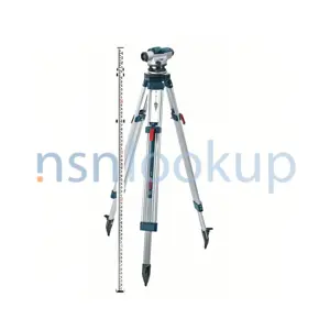
Reconnaissance and Surveying Instrument Set is a collection of tools and equipment used in the field of surveying and mapping. These instruments are specifically designed to assist in the process of measuring and mapping land features, collecting data, and conducting surveys.

Some common instruments found in a Reconnaissance and Surveying Instrument Set may include:

1. Total Station: A total station is an electronic device used for measuring angles and distances. It combines the functions of a theodolite (for measuring angles) and an electronic distance meter (for measuring distances).

2. GPS Receiver: A GPS receiver is used to determine precise locations on the Earth's surface using signals from satellites. It is commonly used in surveying to establish control points and accurately measure distances.

3. Leveling Instrument: A leveling instrument, such as a level or a digital level, is used to determine height differences or elevations between different points on the ground. It is essential for creating accurate topographic maps.

4. Measuring Tape: A measuring tape is a flexible ruler used to measure distances on the ground. It is commonly used for linear measurements in surveying.

5. Tripod: A tripod is a three-legged stand used to support surveying instruments, such as the total station or leveling instrument. It provides stability and allows for precise measurements.

6. Prism Pole: A prism pole is a telescopic pole with a prism at the top. It is used to hold a reflector prism, which is used in conjunction with a total station for measuring distances and angles.

7. Field Notebook: A field notebook is used to record measurements, observations, and other data collected during the surveying process. It is essential for maintaining accurate records and documentation.

These are just a few examples of the instruments that may be included in a Reconnaissance and Surveying Instrument Set. The specific contents may vary depending on the manufacturer and the requirements of the surveying project.

Items Related to 68161 Related Item Names for INC 68161 Reconnaissance And Surveying Instrument Set
Multiplex Equipment Cover Set Surveying Target Set Photogrammetric Vertical Reflecting Projector Curtain Draftsman's Ruling Pen Pivot Drafting Compass Sketching Board Tripod Surveying Tripod Jacob's Staff T-Square Drafting Triangle Parallel Ruler Bench Mark Drawing Board Level Rod Circular Protractor Semicircular Protractor Map Measurer Photogrammetric Stereometer Surveying Alidade Surveying Heliotrope One Arm Protractor Two Arm Protractor Three Arm Protractor Surveying Level Range Pole Surveying Arrow Surveying Arrow Quiver Drawing Board Trestle Drafting Scriber Lettering Scriber Pantograph Integraph Integrator Planimeter Drafting Machine Sketchmaster Surveying Altimeter Drafting Template Straightedge Proportional Drafting Dividers Beam Drafting Compass Stadia Rod Plain Drafting Dividers Drafting Scale Irregular Drafting Curve Level Rod Level Plane Table Board Drawing Board And Plane Table Board Case Drafting Instrument Set Case Company Drafting Equipment Case Drafting And Duplicating Equipment Case Engineer Battalion Drafting Equipment Case Field Artillery Sound Ranging Drafting Equipment Set Case Field Artillery Topographic Surveying Set Case Range Pole Case Regimental Drafting Equipment Case Plotting Scale Level Sight Drafting Center Tack Adjustable Curve Drafting Ruler Adjustable Lettering Line Guide Surveying Elevation And Depression Clinometer Surveying Vertical Collimator Elevation Clinometer Folding Legs Table Surveying Instrument Trivet Aerial Photograph Interpretation Lens-Prism Stereoscope Aerial Photograph Interpretation Lens-Mirror Stereoscope Aerial Photograph Interpretation Lens-Prism-Mirror Stereoscope Aerial Photograph Interpretation Lens Stereoscope Pocket Transit Plotting Tape Beam Drafting Compass Bar Drafting Machine And Drawing Board Photogrammetric Transforming Printer Photogrammetric Projection Printing Rectifier Drawing Board And Trestle Surveying Arrow Set Truck Mounted Topographic Mapping Set Cartographic Section Command Post And Fire Direction Plotting Equipment Set Computing And Drafting Equipment Set Truck Mounted Topographic Mapping Set Copy And Supply Section Drafting And Duplicating Equipment Set Battalion Drafting Equipment Set Company Drafting Equipment Set Supplementary Drafting Equipment Set Headquarters And Service Company Topographic Battalion Drafting Equipment Set Photomapping Company Topographic Battalion Drafting Equipment Set Photographic Interpretation Kit Map Distribution Set Truck Mounted Topographic Mapping Set Map Revision Section Truck Mounted Topographic Mapping Set Photomapping Section Plotting And Computing Set Multiplex Control Booth Stereoplotter Plotting Instrument Set Multiplex Laboratory Stereoplotter Plotting Instrument Set Artillery Fire Control Plotting Set Truck Mounted Topographic Mapping Set Rectifier Section Surveying Instrument Repair Kit Surveying Sketching Set Photogrammetric Stereocomparagraph Stereometer Set Astronomic Azimuth Surveying Set Astronomic Position Surveying Set Field Artillery Battalion Surveying Set Field Artillery Flash Ranging Surveying Set Utility Surveying Set Plane Table Surveying Set Precise Baseline Surveying Set Precise Leveling Surveying Set Precise Traversing Surveying Set Topographic Battalion Supplementary Equipment Surveying Set Topographic Company Surveying Set Triangulation Surveying Set Triangulation Reconnaissance Surveying Set Topographic Photomapping Supplementary Equipment Truck Mounted Surveying Control Section Freehand Lettering Pen Set Scriber-Template Lettering Pen Set Freehand Lettering Pen Lettering Set Scriber Lead Holder Plotting Equipment Chest Surveying Equipment Chest Photogrammetric Vertical Reflecting Projector Projection Stereoplotter Table Projection Stereoplotter Frame Stereoplotter Projector Cooling Unit Surveying Instrument Adjusting Pin Surveying Plane Table Drafting Tracing Table Lettering Set Spline And Weights Set Drafting Instrument Set Drafting Instrument Needle Point Photogrammetric Oblique Photograph Height Finder Stereoplotter Reduction Printer Stereoplotter Projector Photogrammetric Comparator Nonadjustable Lettering Line Guide Surveyor's Bag Beacon Surveying Target Level Rod Cover Lettering Set Case Stereoplotter Projection Frame And Table Assembly Lettering Template Surveyor's Magnetic Compass Surveying Theodolite Transit Surveying Signal Light Drafting Instrument Handle Surveyor's Steel Measuring Tape Tension Handle Stereoplotter Anaglyphic Spectacles Photographic Interpretation Stereoscopic Continuous Strip Viewer Photographic Interpretation Stereoscopic Roll Film Viewer Slotted Template Radial Line Straightedge Projection Stereoplotter Oblique Photograph Interpretation Scale Artillery Fire Control Surveying Set Regular Drafting Curve Set Irregular Drafting Curve Set Drawing Table Elevation Indicator Height Indicator Regular Drafting Curve Distance Indicator Guide Cord Parallel Ruling Straightedge Map Distribution Set Chest Scribing Instrument Point Projection Stereoplotter Tracing Table Portable Illuminated Drawing Board Map Filing Chest Photographic Paper Rolls Chest Stereoplotter Tracing Table Nadirscope Stereoplotter Tracing Table Platen Scriber-Template Lettering Pen Sketching Board Gage Housing Tripod Mount Leg Tripod Mount Leg Section Projection Stereoplotter Repair Kit Geodimeter Reflector Azimuth Surveying Instrument Punched Program Tape Set Polar Coordinates Plotter Rectangular Coordinates Plotter Photogrammetric Diapositive Plates Processing Machine Drafting Template Set Equal Spacing Divider Lettering Pen Cleaning Pin Infrared Electronic Distance Measuring Surveying Instrument Microwave Electronic Distance Measuring Surveying Instrument Micro Electronic Distance Measuring Surveying Set Cartographic Instrument Shop Equipment Technical Fountain Pen Technical Fountain Pen Set Technical Fountain Pen Point Section Surveying Instrument Case Range-Time-Speed Plotting Scale Tooling Set Scribing Map Symbols Drafting Template Tooling Set Semi-Circle One Arm Protractor Tooling Set Topographic Support Set Drawing-Sketching Board Cover Plotter Pens Magazine Digital Topographic Support System Data Transfer Surveying Computer Optical Surveying Instrument Calibration Set Photogrammetric Plotting Autographic Instrument Stereoplotter Tracing Table Lamp Bushing Photogrammetric Slotted Templet Cutter Stereometer Lens And Retainer Ring Multiplex Reduction Printer Lower Pressure Plate Vertical Surveying Collimator Support Area Scale L-Unit Drawing Desk-Table Truck Mounted Surveying System Tribrach Reconnaissance And Surveying Instrument Set Laser Receiver Laser Level Surveying Tripod Leg Point Satellite Signals Surveying Set Ultrasonic Range Meter Marking Flag
NATO Stock Numbers named Reconnaissance And Surveying Instrument Set NATO Stock Numbers with Item Name 68161 Reconnaissance And Surveying Instrument Set Page 1 of 1
19009A0923
RNCC: 7 | RNVC: 2 | DAC: D
ENFR-E-V4
RNCC: 3 | RNVC: 2 | DAC: 3
ENFR-E-V6
RNCC: 3 | RNVC: 2 | DAC: 3
ENFR-E-V5
RNCC: 3 | RNVC: 2 | DAC: 5
ENFR-TSD-07-0004
RNCC: 3 | RNVC: 2 | DAC: 1
771503ASP
RNCC: 3 | RNVC: 2 | DAC: 4
RC-PR4-4P
RNCC: 3 | RNVC: 2 | DAC: 3
RM-25300
RNCC: 3 | RNVC: 2 | DAC: 3