Topographic Photomapping Supplementary Equipment
Item Name Code (INC) 14571
 |
A collection of items which will augment the truck-mounted topographic mapping sets to complete the equipment and supplies required for photomapping operations.
 Additional Information for Topographic Photomapping Supplementary Equipment
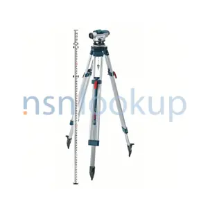
Topographic photomapping supplementary equipment refers to the additional tools and instruments used in conjunction with drafting, surveying, and mapping instruments for the purpose of creating topographic maps using aerial photographs. Some examples of topographic photomapping supplementary equipment are:
1. Stereoscopes: These devices allow the user to view aerial photographs in three dimensions, enabling them to interpret the topographic features accurately.
2. Plotting and measuring tools: These include rulers, protractors, and scales used to measure distances, angles, and dimensions on the aerial photographs.
3. Photogrammetric instruments: These instruments are used to perform photogrammetry, which is the science of making measurements from photographs. They include devices such as photogrammetric plotters, digitizers, and analytical stereoplotters.
4. Image rectification software: This software is used to correct distortions in aerial photographs caused by the camera lens or the terrain, ensuring accurate measurements and mapping.
5. GPS receivers: Global Positioning System (GPS) receivers are used to determine the precise location of ground control points on the aerial photographs, which are essential for accurate mapping.
6. Field surveying equipment: This includes instruments such as total stations, theodolites, and levels, which are used to collect ground control points and other survey data to be used in conjunction with the aerial photographs.
7. Mapping software: Specialized mapping software is used to process the aerial photographs, perform image analysis, and create the final topographic maps.
These are just a few examples of the topographic photomapping supplementary equipment used in the drafting, surveying, and mapping field. The specific equipment required may vary depending on the project requirements and the level of accuracy needed.
Related Item Names for INC 14571 Topographic Photomapping Supplementary Equipment
NATO Stock Numbers with Item Name 14571 Topographic Photomapping Supplementary Equipment Page 1 of 1
- 005431292
- SC6675-93CLE41
- RNCC: 3 | RNVC: 2