Topographic Company Surveying Set
Item Name Code (INC) 14487
 |
A collection of surveying, drafting, computing and office equipment such as a theodolite, scales, computation forms and the like. Used in preparing sketches, maps and similar functions for furnishing geodetic control to field artillery.
 Additional Information for Topographic Company Surveying Set
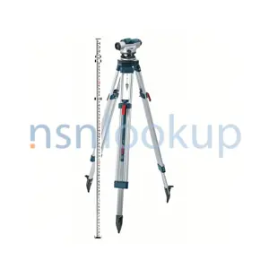
A Topographic Company Surveying Set is a collection of instruments used by surveyors and topographic companies to measure and map the physical features of a piece of land. It typically includes the following instruments:
1. Total Station: A total station is an electronic device that combines a theodolite (for measuring angles) and an electronic distance meter (EDM) to measure both horizontal and vertical distances. It is used to determine the coordinates (latitude, longitude, and elevation) of various points on the land.
2. GPS Receiver: A GPS receiver is used to determine the precise location of points on the Earth's surface using signals from satellites. It is commonly used in conjunction with a total station to enhance the accuracy of measurements.
3. Leveling Instrument: A leveling instrument, such as a dumpy level or an automatic level, is used to measure height differences between points on the land. It is used to create level surfaces and determine elevations.
4. Measuring Tape: A measuring tape is a flexible ruler used to measure distances on the ground. It is commonly used for shorter distances and is essential for taking linear measurements.
5. Tripod: A tripod is a three-legged stand used to support the total station or leveling instrument. It provides stability and allows for precise measurements.
6. Prism Pole: A prism pole is a telescopic pole with a prism at the top. It is used to hold the prism target, which reflects the signals from the total station. The prism pole allows for accurate measurements of distances and angles.
7. Field Notebook: A field notebook is used to record measurements, observations, and other data collected during the surveying process. It is essential for keeping track of information and ensuring accuracy.
These instruments are typically used together to gather data and create detailed topographic maps of the land. They are essential tools for surveyors and topographic companies to accurately measure and document the physical characteristics of a site.
Related Item Names for INC 14487 Topographic Company Surveying Set
NATO Stock Numbers with Item Name 14487 Topographic Company Surveying Set Page 1 of 1
- 010883181
- 79A5043A0000
- RNCC: 3 | RNVC: 2
- 006413601
- SC6675-97CLE27
- RNCC: 3 | RNVC: 9
- 121245692
- B276
- RNCC: 2 | RNVC: 2
- 6675-11456
- RNCC: 6 | RNVC: 9
- 123087336
- 6600173
- RNCC: 2 | RNVC: 2
- 6675-11456
- RNCC: 6 | RNVC: 9
- 131149837
- 571144550
- RNCC: 3 | RNVC: 2
- 160030383
- SUBSTITUTE RN 0090121200814
- RNCC: 3 | RNVC: 9
- 047-00-00
- RNCC: 5 | RNVC: 9
- 661596197
- SCES20182
- RNCC: 3 | RNVC: 2
- 123795665
- 000824041
- RNCC: 3 | RNVC: 2
- 127000642
- 50-79903140070
- RNCC: 2 | RNVC: 2
- 023.003.00
- RNCC: 5 | RNVC: 9
- 023.003.000.000
- RNCC: 5 | RNVC: 9
- 1240-30010
- RNCC: 6 | RNVC: 9
- 127001075
- OST-6675-11456
- RNCC: 2 | RNVC: 2
- 160030385
- SUBSTITUTE RN 0090121300138
- RNCC: 3 | RNVC: 9
- 051-00-00
- RNCC: 5 | RNVC: 9
- 160030384
- SUBSTITUTE RN 0090121300121
- RNCC: 3 | RNVC: 9
- 050-00-00
- RNCC: 5 | RNVC: 9