Topographic Battalion Supplementary Equipment Surveying Set
Item Name Code (INC) 14486
 |
A collection of miscellaneous equipment such as an axe, auger, plumb bob and the like. Used to supplement surveying equipment used by a survey or topographic unit. Not suitable for use as an independent surveying equipment set.
 Additional Information for Topographic Battalion Supplementary Equipment Surveying Set
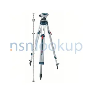
The Topographic Battalion Supplementary Equipment Surveying Set is a collection of instruments used for surveying and mapping in a topographic battalion. It falls under the supply class Drafting, Surveying, and Mapping Instruments, which is part of the supply group Instruments and Laboratory Equipment.
This set typically includes various surveying instruments such as:
1. Total Station: A precision instrument used for measuring angles and distances in surveying and construction projects.
2. Theodolite: An optical instrument used for measuring horizontal and vertical angles in surveying.
3. Leveling Instrument: Used for determining height differences and establishing level reference points.
4. GPS Receiver: Used for obtaining accurate positioning data using signals from satellites.
5. Tripod: A stand used to support the surveying instruments.
6. Measuring Tape: Used for measuring distances on the ground.
7. Prism Pole: A pole with a prism on top used for reflecting signals from surveying instruments.
8. Surveying Markers: Used to mark specific points on the ground for future reference.
These instruments are essential for conducting accurate surveys and creating detailed topographic maps in a topographic battalion.
Related Item Names for INC 14486 Topographic Battalion Supplementary Equipment Surveying Set
NATO Stock Numbers with Item Name 14486 Topographic Battalion Supplementary Equipment Surveying Set Page 1 of 1
- 006413634
- SC6675-97CLE20
- RNCC: 3 | RNVC: 9
- 123700555
- 6600223
- RNCC: 3 | RNVC: 2