Precise Traversing Surveying Set
Item Name Code (INC) 14485
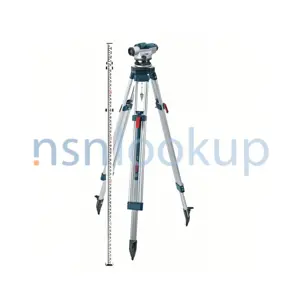 |
A collection of surveying equipment such as theodolite, level, and surveying altimeter. It is used in determining the direction and length of traverse course by both the taping and stadia methods as well as determining elevations by spirit, trigonometric and barometric leveling.
 Additional Information for Precise Traversing Surveying Set
A Precise Traversing Surveying Set is a collection of instruments used in the field of surveying to measure and map land areas. It typically includes the following components:
1. Total Station: A total station is an electronic device that combines the functions of a theodolite (for measuring angles) and an electronic distance meter (for measuring distances). It is used to measure both horizontal and vertical angles, as well as distances, to determine the coordinates of points on the land.
2. Tripod: A tripod is a three-legged stand that holds the total station steady and at a fixed height. It provides stability and allows for precise measurements.
3. Prism: A prism is a reflective target that is placed on a specific point on the land. The total station emits a laser beam that reflects off the prism, allowing for accurate distance measurements.
4. Leveling Rod: A leveling rod is a long, graduated pole used to measure vertical distances or elevations. It is used in conjunction with the total station to determine the height of various points on the land.
5. Data Collector: A data collector is a handheld device that is used to store and manage the data collected by the total station. It allows surveyors to input and edit measurements, as well as perform calculations and generate reports.
6. Accessories: The precise traversing surveying set may also include various accessories such as batteries, chargers, cables, carrying cases, and software for data processing and analysis.
These instruments are essential for conducting precise and accurate land surveys, mapping, and construction projects. They are commonly used by surveyors, engineers, and construction professionals.
Related Item Names for INC 14485 Precise Traversing Surveying Set
NATO Stock Numbers with Item Name 14485 Precise Traversing Surveying Set Page 1 of 1
- 016998379
- SLSU-S2020
- RNCC: 3 | RNVC: 2
- SLSU-S2020
- RNCC: 5 | RNVC: 2