Excludes Training Aid Maps
 Additional Information for Maps, Atlases, Charts, and Globes
NATO Supply Class 7640 is a classification within NATO Supply Group 76, which is dedicated to Books, Maps, and Other Publications.
NATO Supply Class 7640 specifically focuses on Maps, Atlases, Charts, and Globes. This class includes various types of geographical and navigational aids that are used for reference, planning, and navigation purposes.
Maps are graphical representations of geographical areas, displaying various features such as landforms, cities, roads, and boundaries. They can be used for a wide range of purposes, including military operations, transportation planning, and educational purposes.
Atlases are collections of maps, typically organized by region or theme. They provide a comprehensive overview of different areas and can be used for detailed reference or comparative analysis.
Charts are specialized maps used for navigation purposes, particularly in marine and aviation contexts. They provide detailed information about waterways, coastlines, and other navigational features to ensure safe and accurate navigation.
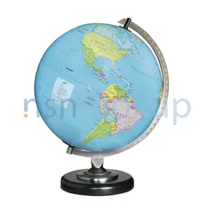
Globes are three-dimensional representations of the Earth, providing a spherical view of the planet's surface. They are often used for educational purposes and can help in understanding the Earth's geography and spatial relationships.
In summary, NATO Supply Class 7640 encompasses various types of maps, atlases, charts, and globes that are used for reference, planning, and navigation purposes. These items play a crucial role in military operations, transportation planning, education, and other fields that require geographical information.
NSN by Country
Frequently Asked Questions(FAQ) for Federal Supply Class 7640
- What is Federal Supply Class 7640?
- FSC 7640 is the Federal Supply Class(formally known as NATO Supply Classification Class NSC 7640) in the USA for supply items codified in the category of Maps, Atlases, Charts, and Globes.
- What is NATO Supply Classification Class 7640?
- NSC 7640 is the NATO Supply Classification Class (also known as Federal Supply Class FSC 7640 in the USA) for supply items codified in the category of Maps, Atlases, Charts, and Globes.
- Which Federal Supply Group is FSC 7640 in?
- FSC 7640 is in Federal Supply Group(FSG) 76 which contains .
- Which NATO Supply Classification Group is NSC 7640 in?
- NSC 7640 is in NATO Supply Classification Group(NSG) 76 which contains .
Supply Items Included in Federal Supply Class 7640
- What is a Chart? 758 Items
- A Chart is a sheet or plate giving printed information in tabular and/or graphic form. It is not intended for, neither does it have provisions for, recording additional information thereon. Excludes maps; CHART, RECORDING INSTRUMENT; PLATE, INSTRUCTION; and SHEET, TECHNICAL.
- What is a Terrestrial Globe? 22 Items
- A Terrestrial Globe (GLOBE,TERRESTRIAL) is a spherical shaped item depicting a map of the earth. It may have other appurtenances reflecting such bodies as the moon, sun, and the like.
- What is a Map Roll Holder? 21 Items
- A Map Roll Holder (HOLDER,MAP ROLL) is an item designed to hold one or several map rolls. May include mountings to fix the item in place as well as securing/locking devices for the map rolls.
- What is a Meteorology Chart? 32 Items
- A Meteorology Chart (CHART,METEOROLOGY) is a synoptic chart, representing on a plain surfaces all or part of earth's surfaces and on which the principal meteorological elements, as temperature, pressure, precipitation, wind direction and the like, at a given hour and over an extended region could be recorded or are recorded.
- What is a Chart Set? 32 Items
- A Chart Set is a combination of several CHART (INC 14232) with or without accessories.
- What is a Map? 45035 Items
- A Map is a sheet or plate representing on a plain surface all or part of earth's surface, showing physical, natural, statistical and/or political features, or division. Excludes CHART; CHART, RECORDING INSTRUMENT; PLATE, INSTRUCTION; and SHEET, TECHNICAL.
Stock Items From Supply Class 7640 Page 2of 137
- 221258662
- M745L3552U4
- RNCC: 3 | RNVC: 2
- 221229710
- M745L3752U3
- RNCC: 3 | RNVC: 2
- 221253401
- M745L4322U5
- RNCC: 3 | RNVC: 2
- 221229892
- M645C1918U6
- RNCC: 3 | RNVC: 2
- 221216599
- M7151314IVU3
- RNCC: 3 | RNVC: 2
- 221165559
- RPMM745L2526U5
- RNCC: 3 | RNVC: 2
- 221253514
- M745L3336U5
- RNCC: 3 | RNVC: 2
- 221217079
- M745L2716U6
- RNCC: 3 | RNVC: 2
- 016134069
- 65-66257-2
- RNCC: 3 | RNVC: 2
- 016134070
- 65-66257-8
- RNCC: 3 | RNVC: 2
- 014546127
- 2200013-201
- RNCC: 3 | RNVC: 2
- 014544292
- CTSS
- RNCC: 3 | RNVC: 1
- 013837230
- 003-0762-00
- RNCC: 3 | RNVC: 2
- 013793988
- 7120-0642
- RNCC: 3 | RNVC: 2
- 013648571
- JA-20-2019
- RNCC: 3 | RNVC: 2
- 92-5-14-1 CC
- RNCC: 5 | RNVC: 1
- F92D478
- RNCC: 5 | RNVC: 1
- 013292977
- 4012.151.49921
- RNCC: 3 | RNVC: 9
- 013195562
- 9050A
- RNCC: 3 | RNVC: 2
- 013040940
- 8368-10
- RNCC: 3 | RNVC: 2
- 012888598
- M711-1131-II-02
- RNCC: 3 | RNVC: 2
- 012868381
- SEHS7860-01
- RNCC: 3 | RNVC: 2
- 012718561
- 174566-001-0011
- RNCC: 3 | RNVC: 2
- 012318855
- 7594949G1
- RNCC: 3 | RNVC: 2
- 012318854
- 7594949G2
- RNCC: 3 | RNVC: 2
- 011597278
- 412656-1
- RNCC: 3 | RNVC: 2
- 011103515
- 11834421
- RNCC: 3 | RNVC: 2
- 010672330
- 7732990-03
- RNCC: 3 | RNVC: 2
- 010672329
- 7732990-01
- RNCC: 3 | RNVC: 2
- 008948757
- 593
- RNCC: 3 | RNVC: 9
- 008948758
- P1630
- RNCC: 3 | RNVC: 2
- 008948759
- SR206
- RNCC: 3 | RNVC: 2
- 008253882
- 427626-4
- RNCC: 3 | RNVC: 2