Premium Information is available for this item - Upgrade for $1 a day
7010-01-657-1240
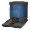
Geospatial Intelligence Workstation
7010016571240 016571240 A3359854
A tactical, computer-based system that allows the Geospatial Intelligence Analyst to utilize hardcopy and digital terrain data to produce real time and near real time information for the battlefield commander. It also allows for the hardcopy production of large format, multicolor topographic products in a timely manner. It comes in a Light version and a Deployable version. The Light version has the equipment installed in a shelter mounted on the back of a vehicle with a towed generator and the Deployable version is fitted in transit cases. This item is a member of the DISTRIBUTED COMMON GROUND SYSTEM - Army family of systems. View more Geospatial Intelligence Workstation
![]()
January 2023
1

 Marketplace 7010-01-657-1240
Request a Quotation from participating marketplace vendors
Related Documents 7010-01-657-1240 5+ Documents (More...)
Intelligence Workstation A3359854 A tactical, computer-based Intelligence Workstation A3359854 A tactical
Geospatial Intelligence Workstation computer-based Intelligence Workstation A3359854 A tactical
Workstation,K543480 https//www.nsnlookup.com /fsg-70 https//www.nsnlookup.com /fsg-70/fsc-7010/us 7010-01-657-1240
Geospatial Intelligence Workstation www.nsnlookup.com /fsg-70/fsc-7010/us 7010-01-657-1240 https
7010/uk 7010-99 https//www.nsnlookup.com /fsg-70/fsc-7010/us 7010-01-605-1985 /fsg /fsc-7010/us 7010-01-657-1240
7010/us 7010-01-605-1985 Geospatial Intelligence https//www.nsnlookup.com /fsg-70/fsc-7010/us 7010-01-657-1240
Geospatial Intelligence Workstation www.nsnlookup.com /fsg-70/fsc-7010/us 7010-01-657-1240 https
Geospatial Intelligence Workstation -01-625-4071 https fsc-7010/us 7010-01-657-1240 https//www.nsnlookup.com
/fsg-70/fsc-7010/us 7010-01-483-0563 www.nsnlookup.com /fsg-70/fsc-7010/us 7010-01-657-1240 https //
Restrictions 7010-01-657-1240
7010-01-657-1240 is a Geospatial Intelligence Workstation that does not have a nuclear hardened feature or any other critical feature such as tolerance, fit restriction or application. Demilitarization of this item has been confirmed and is not currently subject to changes. This item a security classified item on the US Munitions List and demilitarization is required. This item is not suspected to be hazardous. This item does not contain a precious metal. This item is sensitive to Electrostatic Discharge.
End Users 7010-01-657-1240
- US Army (A502)
- Effective Date:
- 1 Jul 2016
Approved Sources 7010-01-657-1240
- Part Number
- Manufacturer
- Status
- A3359854
- Manufacturer
- 371C6 - Chs Inc (Active)
- Primary Buy
- Primary Buy
Datasheet 7010-01-657-1240
- Characteristic
- Specifications
- FIIG
- Specifications
- A554P0
- Document Source [AJJY]
- 80063
- End Item Identification [AGAV]
- An/Tyq-71C(V)3
- End Item Source [AJKE]
- 67032
- Container Type [ALQG]
- Case
- Part Name Assigned By Controlling Agency [CXCY]
- Workstation,Geospatial Intelligence
- Unpackaged Unit Height [AJAH]
- 48.0 Inches Nominal
- Unpackaged Unit Width [AJAG]
- 144.0 Inches Nominal
- Unit Package Quantity [AGUC]
- 8
- Usage Design [ALCD]
- Used To Produce Maps,Overlays,Graphic Images
Management Data 7010-01-657-1240
- Effective Date
- Organization
- Unit of Issue
- Unit Price
- Qty Unit Pack
- Unit of Issue
- Dec 2016
- Department of the Army (DA)
- EA
- Subscribe
- 1
- EA
 Army
Army
- Materiel Category and Inventory Manager:
- G
- Communications and Electronics Equipment, Electronics Materiel
- Appropriation and Budget Activity:
- P
- Communications and Electronics Equipment (except Safeguard)
- Management Inventory Segment:
- 1
- Repairable Items(Exclusive of Insurance and Provisioning Items)
This code will be used to identify serviceable or unserviceable items of a durable nature, which when unserviceable normally can be repaired economically by depots or lower echelons of maintenance.
- Weapons System / End Item / Homogeneous Group:
- 4R
- Communications System Agency and Satellite Communications Agency Equipment
Digital Topographic Support System (DTSS) AN/TYQ-67 Geospatial Workstation (GWS) AN/TYQ- 71
- Accounting Requirements:
- N
- Nonexpendable item.An item of Army property coded with an ARC of N in the AMDF.Nonexpendable items require property book accountability after issue from the stock record account.Commercial and fabricated items similar to items coded N in the AMDF are considered nonexpendable items.
Similar Supply Items to 7010-01-657-1240


Freight Information 7010-01-657-1240
7010-01-657-1240 has freight characteristics.. 7010-01-657-1240 has a variance between NMFC and UFC when transported by rail and the description should be consulted.